As far back as the hillfort period, gold was extracted in a more or less systematic way, but it was after the Roman conquest (1st–3rd centuries AD) that gold mining became established in the northwest of the Peninsula as a large-scale industrial activity.
The Romans followed the gold veins and, by panning the rivers, worked their way up the valleys until they found the precious treasure. The Roman mining system, ruina montium “collapse of the mountains”, consisted of bringing down large sections of rock by using water pressure as it entered through purpose-dug galleries. In this way, according to Pliny the Elder, more than 6 tonnes/year were extracted from the mines of northwestern Hispania. These incredible volumes made it necessary to build the first transport routes, which would link the major mining operations and transport the ore. The water transport and storage systems used by the Romans were the same as those used by the Egyptians in earlier centuries.
In total, there are 487 gold deposits in Asturias, all in the west and almost all already worked by the Romans. In fact, by analysing satellite images—where the main tectonic features of our region can be recognised—it can be seen that it is in relation to the main faults and thrusts, areas where there is an anomalous accumulation of minerals, that some kind of Roman mining trace can be found… how clever the Romans were…!
More than 5,000 miners worked the Asturian deposits to extract, in a single century, more than 100 tonnes of gold. Roman gold mining did not disappear due to resource depletion, but because of rising labour costs and the collapse of the Roman monetary system.
After 2,000 years of abandonment, many of the scars in the topography are still visible in our landscapes, as well as the remains of the channel and gallery systems used to convey water.
Some examples of this Roman mining activity are the Covas de Andina and the Cárbobas de Miudes in El Franco; Serandinas and the Cabrucal de Trelles in Boal; and the Salave Mines in Tapia de Casariego. As it is considered the largest gold deposit in Western Europe, one of the few known examples of coastal Roman-period gold mining on the Peninsula, and a current issue with strong social and economic implications, we will focus on the Salave Mines.
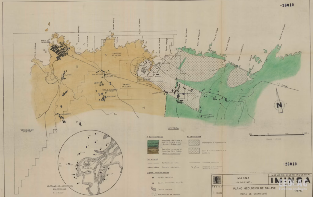
Where does Salave’s gold come from?
A quick look at the geological map of the area is enough to realise that the Salave area has a geological peculiarity in Asturias: granites!
Igneous rocks in Asturias are very scarce, with sedimentary rocks dominating our territory (sandstones, slates, limestones, etc.). Igneous or plutonic rocks, such as the granodiorites and gabbros of Salave, come from the Earth’s interior. The fractures through which the magma rose facilitated the circulation of hot (hydrothermal) fluids that altered the granodiorite and gave rise to the mineralisation of gold and other metals (arsenic, molybdenum, antimony, copper, etc.).
But why are there granites in Asturias?
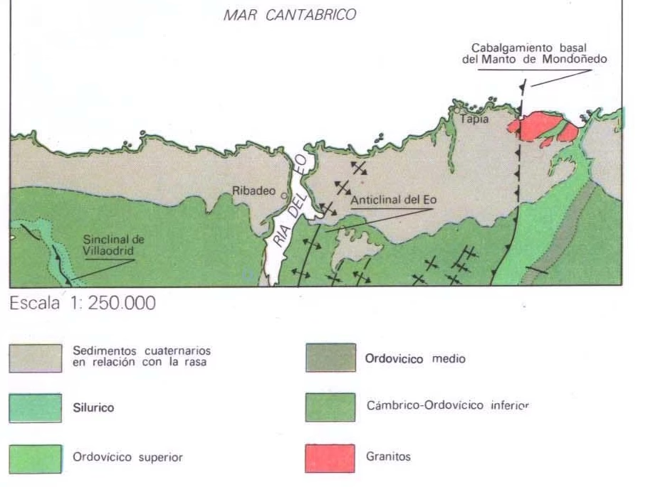
About 285 million years ago, Laurasia collided with another great continent to the south, Gondwana, giving rise to the supercontinent Pangaea. This collision took place in what is now Galicia, which is why it is in this territory and in western Asturias that the rocks show the clearest signs of those upheavals. During the formation of Pangaea, magma rose through the fractures produced by the collision. One of those magma bodies formed the Salave granodiorite, the rock that hosts the gold. Several million years later, new tectonic movements, together with erosional processes, allowed the granodiorite to outcrop at the surface, and so we can observe it today.
The Salave mines. The Asturian “Médulas”
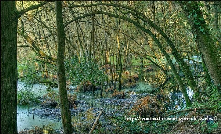
At the Salave mine, in Tapia de Casariego, not only were kilometres of channels and galleries used to move the water needed to fracture the rock, but the movement of huge volumes of material drastically altered the area’s original topography. The removal of material created a deep depression more than 30 m deep, in which water accumulated due to the impermeable nature of the substrate and the proximity of the water table (which here practically coincides with sea level). This is how the Silva Lakes formed.
Using the ruina montium, more than 10 ha were dismantled at Salave to a depth of more than 20 m. More than 4 million m3 were moved, extracting more than 7,000 kg of gold.
Incredible figures that barely come close to those of the largest open-pit gold mine in the entire Roman Empire: Las Médulas (León), where an area of around 1,228 ha was modified and more than 93 million m3 of earth were moved. At Las Médulas there was an extensive network of channels and galleries more than 300 km long. Although more discreet, Salave’s water-capture and supply channel system is still impressive, as it runs almost 20 km from the Porcía River, where the La Barrosa dam once stood, the last remains of which disappeared after severe floods that devastated Asturias in 1935. This channel, known as the Canal de los Moros, has left its mark on our place names: Peña Cortada corresponds to the cut they must have made in the mountain to allow the water to pass. Around the area affected by the ruina montium, radial galleries carved into the rock can be seen, which must have been the working and extraction channels. From the flooded area and cutting through the cliff, at least three drainage channels at different levels are preserved, which discharged excess water directly into the sea. The mouths of both drainage channels are visible at Figo Beach and, even today, they continue to drain the area. At the mouth of the channel, at Figo, Roman mills have been found that may have been used to grind and liberate the gold ore (Ochoa 1979).
A couple of deep channels, where deposition and screening work was probably carried out, connect the edges of the great lake depression with the nearby cliff.
The mining population at Salave is estimated to have been around 200 people. Most of these workers were free natives who lived in nearby hillforts (the hillforts of Figo and Castello de Rondello). The management of mining engineering and logistics was carried out by soldiers, who, together with other officials in charge of administration, were based here.
The gold war
The Salave mine remained quiet for more than 2,000 years until 1825, the year the first Mining Law was enacted, when the area became the subject of dozens of claims and mining concessions for various metals. Exploitation permits were requested from 1825 to 1964 for silver, molybdenum, iron, copper, zinc, tin, tungsten, etc.
In 1830 the lakes were drained for a failed operation, and between 1948 and 1952 five galleries were driven in the western sector of the Roman pit, where molybdenite was mined, about 250 g/Tm. Molybdenum was used to add strength to iron. As a result of that extractive period, part of this wetland was filled in.
Many companies have passed through Tapia since the 1960s to investigate the Salave gold deposit. Exminesa (Cominco), Imebesa (Northgate), Río Tinto Patiño, GFSA (Gold Fields), CESA Charter Exploraciones (Anglo-American), Oromet, Newmont Gold Company (Newmont Minig Corporation), San Diego Gold Company (Lindex Exploration), Río Narcea Gold Mines, and the current owner Dagilev Capital Corporation (Astur Gold) are some of the names that resonate in the area. In total, nearly 62 kilometres of drilling were carried out by all the companies. In those years, samples from Salave were flown to South Africa, England, or the USA to be analysed and assess their economic potential.
Río Narcea Gold Mines submitted an open-pit mine project in 2005 that was rejected by the Principality for environmental reasons, as it would have meant a “furaco” 600 metres in diameter and 212 m deep. In 2010, Astur Gold, the new owner of the mining rights, opted for underground mining, much less aggressive to nature but still facing strong opposition.
This is a deposit located right on the coast, whose exploitation would involve enormous earth movements and the use of chemical processes to treat the extracted ore. It therefore poses a high risk of pollution in an area of great environmental value.
Protection for the Salave Mines
Although there have been some attempts in recent years to include the Salave area in the Asturias Network of Protected Areas, to date it is an area with no protection status whatsoever. To its landscape and archaeological value we must add its high biological value, since the Silva Lakes, formed as a result of mining at Salave, constitute one of the few wetlands in Asturias.
The surroundings of the Salave Mines bring together a set of elements linked to the exploitation of the area’s mineral resources that fully deserve study, conservation, and protection. By way of example, in the case of Las Médulas the archaeological remains of mining and its associated landscape were declared a Site of Cultural Interest in 1996, a World Heritage Site in 1997, and a Natural Monument in 2002.
At Salave, many elements of Roman mining are preserved: extraction faces, a supply channel, a gold-washing area, three drainage galleries, channel trenches, two drainage channels, the location and part of the reservoirs, etc. Neither the Silva Lakes site nor the hillforts associated with the site have been the subject of archaeological campaigns, which means we do not know their true historical and archaeological value.
The lack of protection for this area has led to actions that are far from desirable for its study and conservation, such as filling in one of the lagoons without proper oversight. It should be borne in mind that lake areas are often ideal environments for the preservation and recovery of archaeological material, due to the anoxic conditions that characterise these settings.
In addition to their interest for the preservation of archaeological material, the Silva Lakes represent a singular environment with the presence of protected flora and fauna species. These include the common bladderwort and the marsh lady fern, of which there are only three populations in Asturias, as well as the water milfoil, which in the entire Principality is found only in Salave.
There are therefore more than enough reasons to protect and enhance the Salave area. Its points of interest, properly uncovered, signposted, and interpreted through guided itineraries, would allow Salave to become a tourist benchmark in the same way as other Cantabrian mining sites such as Las Médulas, Cabárceno, or the Cuevas de Andina. Likewise, the Silva Lakes could be restored for biological itineraries.
And the fact is, Salave… really does hide a treasure!
Would you like to discover this landscape with a geologist?
GEOLAG organises educational routes adapted to families, groups and schools.
Request information about this route