Somiedo Lakes: glacial origin, dolomites and a geological route
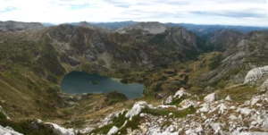
Why are there lakes in an area dominated by limestone? The Somiedo Lakes hide a story of glaciers, dolomitisation, iron mining and unique high-mountain landscapes in Asturias.

Why are there lakes in an area dominated by limestone? The Somiedo Lakes hide a story of glaciers, dolomitisation, iron mining and unique high-mountain landscapes in Asturias.
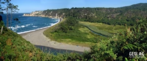
Barayo is much more than just a beach: it is a protected estuary where the geology explains the shape of the landscape, the course of the river, the dunes, and the cliffs. It’s the perfect excursion for exploring the Cantabrian coastline from a geological perspective.
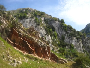
The Route of the Xanas lets you discover one of Asturias’ most spectacular gorges through a geological lens. A trail through limestone, sandstone, faults, folds and water-carved landscapes, ideal for interpreting the formation of this gorge between Proaza, Serandi and Pedroveya.
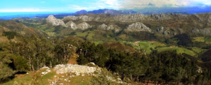
The Sierra del Sueve combines karst geology, unique forests, and iconic wildlife at one of the best viewpoints in Asturias. A journey through sinkholes, Asturcones, fallow deer, Picu Pienzu, and the La Biescona beech forest overlooking the Cantabrian Sea.
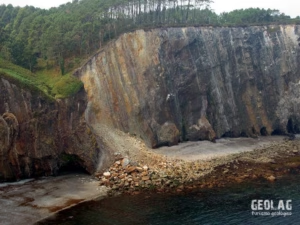
The Asturian coast is a living landscape where beaches, cliffs, dunes, estuaries, and coastal platforms (rasas) tell the geological history of the northern Iberian Peninsula. Along its more than 350 km of coastline, between the Tinamayor and Eo estuaries, the variety of rocks and structures dictates the shape of the coast: from the cliffs and pebble beaches of the west to the limestone landscapes of the east, including the large sandy areas and dune systems fed by rivers. An educational journey to understand how the sea, rocks, sediments, and time have modeled one of the most diverse coastlines of the Cantabrian Sea.
Somiedo was the first area in Asturias to be declared a Natural Park in 1988 and, in 2000, it was also included in the Natura 2000 Network as a Biosphere Reserve.
The Samuel Path PR-AS-284 is a low-difficulty circular route that combines nature, geology, and local history between Llames de Pría, Cuerres, and Ribadesella. Along the Guadamía River, the path reveals a peaceful landscape of fertile plains, limestone formations, small waterfalls, and unique spots such as the medieval Mía bridge, with the option to extend the walk to the impressive Bufones de Pría.