The origin of the Picos de Europa National Park dates back to 1918 when, on the initiative of the Marquis of Villaviciosa Don Pedro Pidal, the first National Park in Spain was declared: The Covadonga Mountain National Park. On this route, we will explore the landscapes that captivated the Marquis and motivated its inclusion in the Spanish network of protected landscapes. In 1995, the Park was expanded to its current territory and renamed the Picos de Europa National Park, becoming the second most visited national park in Spain, after Teide National Park (Tenerife). In 2003, UNESCO approved the proposal that designated it a Biosphere Reserve.
It should be noted that during Easter, certain long weekends, and throughout the summer, the Covadonga Lakes Transport Plan operates from Cangas de Onís. The access plan to the Lakes by public transport aims to protect the Picos de Europa National Park (Biosphere Reserve) during periods of high tourist influx. The rest of the time, access is free. On the National Parks Network page below, you can consult all updated information:
Access is free for disabled persons with accredited vehicles, and organized group buses require a special permit to enter. During regulated periods, a fleet of buses ensures the transfer of all visitors between Cangas de Onís, Covadonga, and the lakes, making stops at the main points of interest along the route, including hotels and activity establishments. Four authorized car parks (with 1,600 spaces) are available in Cangas de Onís Centro-P1, El Bosque-P2, Muñigo-P3, and El Repelao-P4.
From July 1st to September 30th, the Park offers a guided tour service, including routes in the Sajambre area (León), Liébana (Cantabria), Cabrales (Asturias), and the Lakes area, where today’s excursion will take place. Departures will be from the Buferrera car park at 10:30 AM, and specialized guides will talk about flora, fauna, ethnography, and, of course, Geology.
This is an easy route, ideal for families, with a duration of 3 hours and an elevation gain of 220 m.
Pedro Pidal Interpretation Center
Our starting point will be the Pedro Pidal Interpretation Center in Buferrera, which hosts various exhibitions that facilitate understanding of the Natural Environment, orography, and history of the Park. It also shows some general aspects of Geology, and we can see a model of the Trave System, which, at 1441 m, is one of the deepest cave systems in the world. Thirteen of the world’s deepest caves are located in the Picos de Europa, making them a paradise for speleologists.
At this center, we can acquire the Geological Guide to the Picos de Europa National Park, an accessible book featuring 14 routes through the Picos de Europa, published on the initiative of the IGME and the Autonomous Parks Organization and edited by Adrados Ediciones, in which I myself participated as co-author, layout designer, and illustrator. This publication can serve as the basis for our excursions for hikers interested in learning more about the environment through which their routes pass.
From the Interpretation Center, we will head north, where we can look out over the Vega de Comeya, a wide meadow that once must have been a large lake that disappeared more than 8000 years ago, forming a large peat bog that was the origin of an exploitation, whose remains are still preserved.
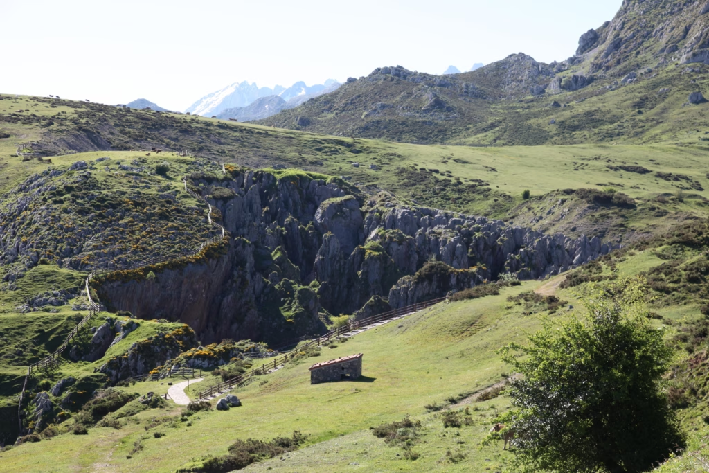
Buferrera Mines
Another exploitation found in the vicinity of the Lakes are the Buferrera mines. This was an operation where manganese and iron were extracted until 1979, minerals found in the cracks and cavities of the limestones that form the Picos de Europa in this sector.
How were the Covadonga Lakes formed?
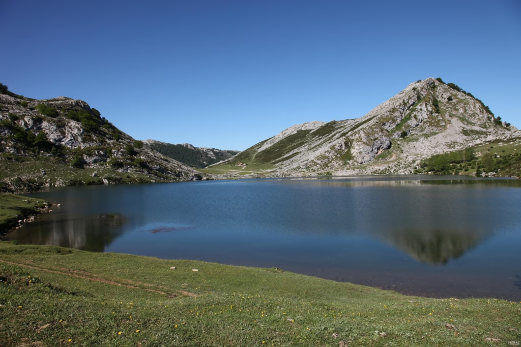
About 40,000 years ago, the last glacial maximum affected the Cantabrian mountains. At that time, the three massifs that make up the Picos de Europa were covered by large ice caps that, in some areas, such as the nearby Jou Santu, reached 300 m thick. Ice is a highly erosive agent whose movement causes the rapid destruction of rock at the bottom and on the walls of glacial valleys. Like an excavator, the detached material is transported by the ice down the valley and accumulated at the base, on the sides of the ice tongue, and at the confluence of several glacial tongues. These types of deposits of ice-transported materials are called moraines, and depending on their position, they are called basal, lateral, central, or frontal moraines. In Covadonga, we can observe all these types of moraines. The Buferrera mines themselves were excavated on a lateral moraine of a glacier that came from the highest peaks rising before us. The ridge separating Lake Enol and Lake Ercina, called La Picota due to its sharp morphology, is nothing more than a central moraine, formed as a result of the confluence of the Ercina glaciers and another that descended through the Vega de Enol. It is recommended to climb to the ridge itself, from where you will have magnificent views of both lakes and the entire surroundings. In both lakes, water retention is possible due to the existence of frontal moraines that act as a dam. The entire bottom of both valleys is covered with glacial materials that constitute the basal moraines.
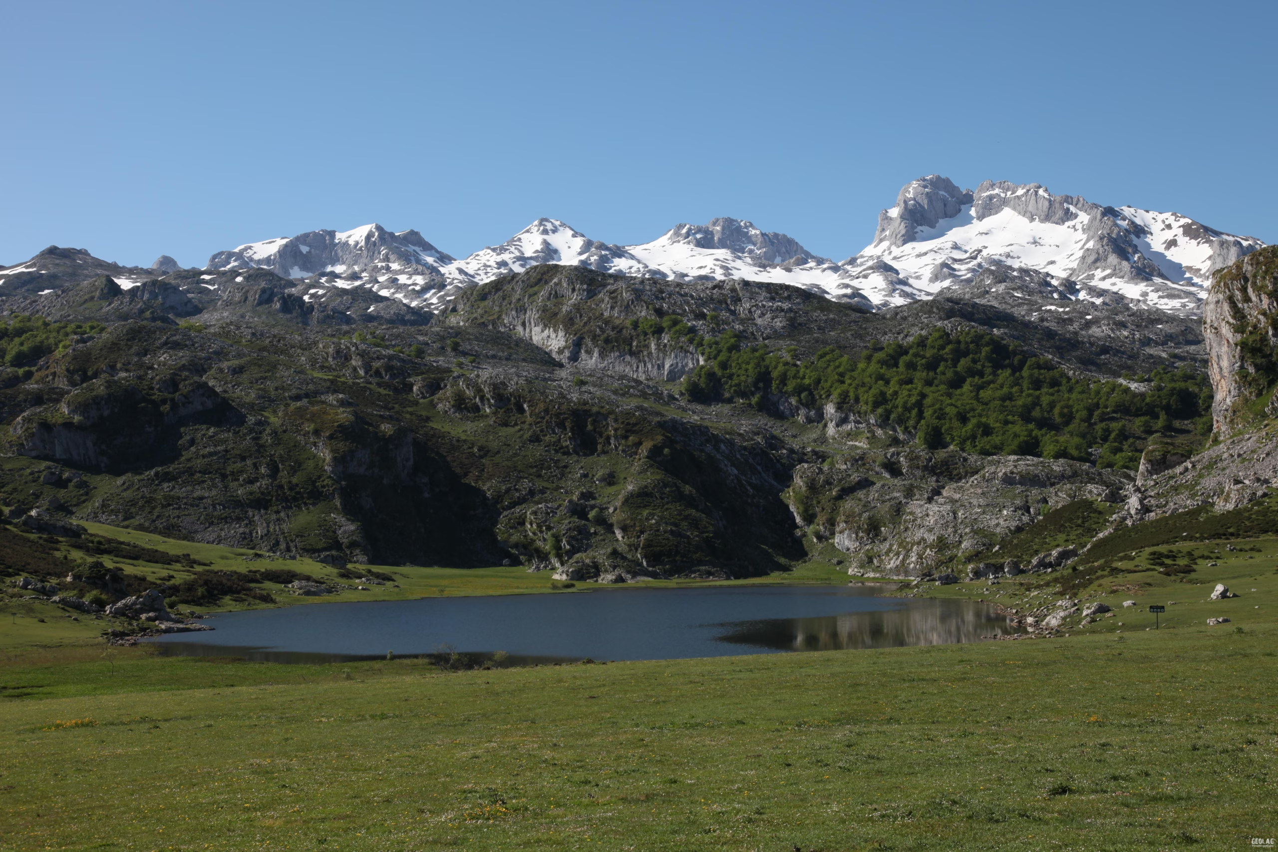
Lake Ercina
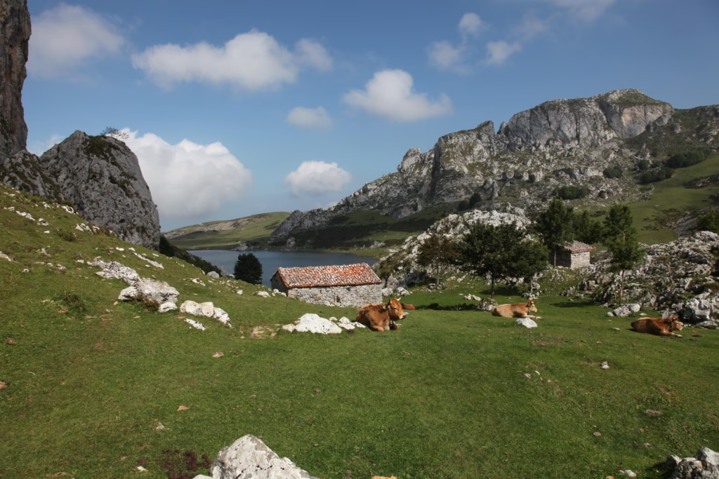
We continue our journey along the right (west) bank of Lake Ercina. Lake Ercina is a shallow lake and was the main water source for the Buferrera mines. If it weren’t for the dams that the miners built at its southern end, this lake would have already disappeared, as its water naturally drains through a cavity on its southern edge. From the mines, we will head towards Lake Ercina, one of the three lakes found in Covadonga, along with Lake Enol and the ephemeral Lake El Bricial. These are some of the few lakes found in the Picos de Europa, and the largest. The absence of lakes in the Picos de Europa is due to the almost predominant presence of limestone in these mountains. Limestone is a permeable rock that prevents water circulation on its surface, hence the scarcity of rivers in these areas. In Covadonga, the presence of slate in this area has made possible the formation of the impermeable basin that houses the lakes.
Around the lake, the accumulations of large blocks at the base of the main reliefs are striking. These block avalanches were caused by the retreat of the ice. The powerful ice sheet that once occupied this area exerted strong pressure against the walls of the glacial valley. When the ice disappeared, these tensions relaxed, causing the mountains to expand laterally, leading to large rock avalanches and rockfalls.
Las Reblagas
After crossing Lake Ercina, we arrive at the Las Reblagas area, where we find a small stone cabin that once served as shelter for shepherds who came up to tend their livestock in the summer. Today, a shepherdess sells eggs and the prized and very expensive Gamonéu cheese, which is cured right there in the cabin by the warmth of the fire (or so they say…).
The Third Lake. Lake Bricial
Circling El Mosquital, a peak separating Lake Enol and Lake Ercina, a wide flat area stands out amidst the rugged terrain around us. This is the Vega del Bricial, an area that, during periods of heavy rainfall or after snowmelt, floods, forming the ephemeral Lake El Bricial, whose waters tend to disappear into the limestone rock. The El Resecu stream is responsible for supplying water, and during floods, it forms a striking waterfall upon its arrival at the meadow, called La Meona.
Karst
We continue circling El Mosquital through an intricate landscape of holes, and cracked and grooved rocks of curious shapes. This is the typical modeling of limestone regions. Rainwater, in contact with calcium carbonate, dissolves the rock, forming channels and sinkholes. During spring, it is common to see small riverbeds that appear and disappear suddenly in these holes.
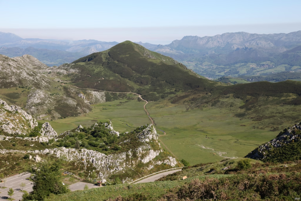
Vega de Enol
We will cross the Vega de Enol to head towards Lake Enol. Every July 25th, the Vega de Enol becomes the setting for the Shepherd’s Festival, celebrated since 1939 and declared a Festival of National Tourist Interest. From Cangas de Onís, at precisely eight in the morning, pilgrims set off for the meadow of Lake Enol, this being the only night of the year when camping is allowed. The festival begins with the traditional mass in the Chapel of the Good Shepherd at ten in the morning. Once the mass is over, the Open Council of the Corporation and the Council of Shepherds meet. Once assembled, the equitable distribution of pastures is carried out, the pasture administrator who is responsible for enforcing the law is chosen, and the most beautiful shepherdess is selected. During the day, rural games, bareback horse racing, a traditional craft exhibition-competition, performances by folk groups, and the ascent of the Porra de Enol take place. In 1994, the community of shepherds of the Picos de Europa received the Prince of Asturias Award for Exemplary Town.
In the Vega de Enol, a set of holes stands out on the meadow. This entire meadow is covered with materials transported by the Enol glacier. The presence of numerous sinkholes in the limestone substrate beneath the glacial deposits causes this material to tend to sink into these gaps, which is reflected on the surface by the formation of subcircular depressions called boches.
The return to the car park from where we started can be made either along the right edge of the lake (a narrow path) or along its left bank (track and road). Once on the other side of Lake Enol, we will look back to admire the wide glacial valley with its typical U-shaped morphology formed by the Enol glacier.
The Sanctuary of Covadonga
A visit to the Sanctuary of Covadonga is a must, as it is the origin of the Kingdom of Asturias and a pilgrimage site for the Christian world. In this sector, the Cave housing the image of the Virgin of Covadonga, our patron saint, stands out, but the most striking feature is the waterfall that springs just below the chapel. This is the resurgence of the Orandi river, which, after sinking into the Vega of the same name, emerges through the cave.Documentation
- Geological Guide to the Picos de Europa National Park. 14 geological itineraries. Adrados Ediciones. 2nd edition 2013.
- Picos de Europa National Park. Ring of Refuges. Topographic hiking map scale 1:50,000. Adrados Ediciones. 2012
- Picos de Europa and Eastern Coast of Asturias. Topographic hiking map with 50 pedestrian itineraries. Scale 1:80,000. Adrados Ediciones
- Picos de Europa. Western Massif (El Cornión). Topographic hiking map scale 1:25,000. Adrados Ediciones. 2009
Do you want to discover this landscape with a geologist?
GEOLAG organizes informative routes adapted for families, groups, and educational centers.
Request information about this route