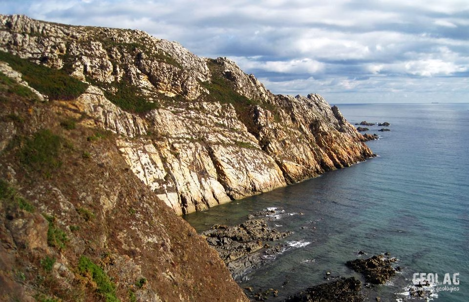
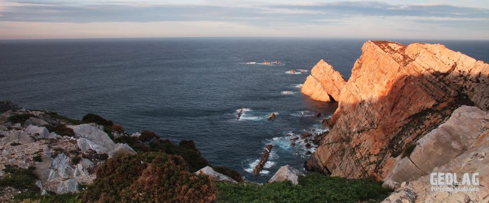
Today we are staying on the central coast of Asturias to explore its geology in an exceptional location: Cabo Peñas. In green and lush Asturias, cliffs are among the best places to see rocks. Its status as a natural viewpoint also makes it a site of undeniable scenic value that we will attempt to analyze in detail.
The coastal strip of the Cabo Peñas region offers exceptional conditions for identifying the main geological features of central Asturias. In this area, a wide variety of rock types and fossils can be recognized, along with all the elements of a cliff landscape. All of this is very close to the main population centers, so there is no excuse not to visit.
Our route will take us between Cabo Peñas and Cabo Torres, near Gijón. This area enjoys several levels of European protection, being a Special Protection Area for Birds (SPA) and a Site of Community Importance (SCI) from the Esva River to Luanco, as well as a Protected Landscape within the Asturias Natural Resources Management Plan (PORNA). These protection statuses reflect the natural values encompassed within this narrow coastal strip.
The rocks of Cabo Peñas
As we discussed in the last program before the holidays, the characteristics of the rocks outcropping on the coast condition the shape of the cliffs and beaches in each sector. We mentioned that at Cabo Peñas, there is a great diversity of rocks spanning a period of more than 500 million years.
Thus, at Cabo Peñas itself, Ordovician rocks (500 million years ago) outcrop; in the Llumeres inlet, the Silurian outcrops; and from Bañugues to El Tranqueru, Devonian materials appear, folded into two large synclinal folds whose cores contain younger rocks, in this case from the Carboniferous. (A synclinal fold is U-shaped and houses younger rocks in its core than on its flanks).
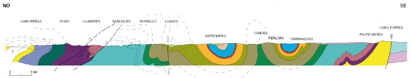
In Aboño and Cabo Torres, the rocks are Silurian again as we are on the flank of said syncline. Above these deposits, there are other younger materials discordant over the previous Ordovician, Silurian, Devonian, and Carboniferous materials, corresponding to the Permian and Triassic (250-200 million years ago) appearing in the Tranqueru area (between Perlora and Xivares), and the Cretaceous (65 million years ago), represented at Antromero Beach. What makes the Cabo Peñas area special from a geological perspective is the representation of rocks that do not appear or are poorly represented in other sectors of Asturias, such as Silurian or Devonian materials. With this exceptional rock record, it is possible to reconstruct the history of Asturias over the last 500 million years.
The journey of Asturias toward the North
Most of the rocks that outcrop in Asturias are sedimentary rocks; that is, they are rocks that have been deposited over millions of years by agents such as the sea, rivers, etc. At the time these rocks were deposited, their arrangement was horizontal. Today, all these rocks are verticalized as a consequence of the movement and collision of tectonic plates throughout the geological history of our planet.
500 million years ago, in the Ordovician, Asturias was located on the edge of a “supercontinent” called Gondwana, very close to the South Pole. Over millions of years, Gondwana moved toward more northerly positions until, about 400 million years ago, it was located near the Tropics. At that time, Asturias would have been situated under a sea very rich in fauna typical of warm seas.
About 350 million years ago, Gondwana’s journey northward was interrupted by its collision with another supercontinent formed by Laurentia and Baltica. This collision was one of the main events related to the Hercynian Orogeny, which gave rise to the Variscan Orogen. This orogeny folded and fractured previous materials while deforming those being deposited at that time. When the mountain range finished forming, erosive processes began to progressively dismantle that majestic range, which would have been similar to the current Himalayas. The product of this erosion was deposited over the previously deformed materials, creating a surface known in geology as an angular unconformity, where the materials on either side of the unconformity have very different ages, inclinations, and orientations.

This angular unconformity brings the Carboniferous flysch materials of Antromero into contact with the Cretaceous materials of the Mesozoic-Tertiary Cover that blankets central Asturias.
To see an example of an angular unconformity, we move to Antromero Beach, between Luanco and Candás. In this case, it is an unconformity that brings the Carboniferous—folded and verticalized as a result of the Variscan Orogeny—into contact with the Cretaceous, which has a practically horizontal arrangement. The existence of an unconformity implies a gap in the sedimentary record; that is, there are no rocks between the Carboniferous (300 million years ago) and the Cretaceous (65 million years ago). This may be because there was strong erosion during that period that dismantled those rocks and carried them elsewhere, or simply because there was no sedimentation.

How do we know where Asturias was at each moment in Earth’s history?
On its journey northward, Asturias traveled through different latitudes with different climates, being located in continental, coastal, swampy, or marine terrains depending on the position of the continents in each period. Each rock is linked to a specific sedimentary environment, so it is the rocks that tell us what climate and conditions prevailed at the time of their deposition.
Thus, the Ordovician quartzites that appear at Cabo Peñas itself were formed in coastal environments and are related to the mouths of large rivers with many braided channels.
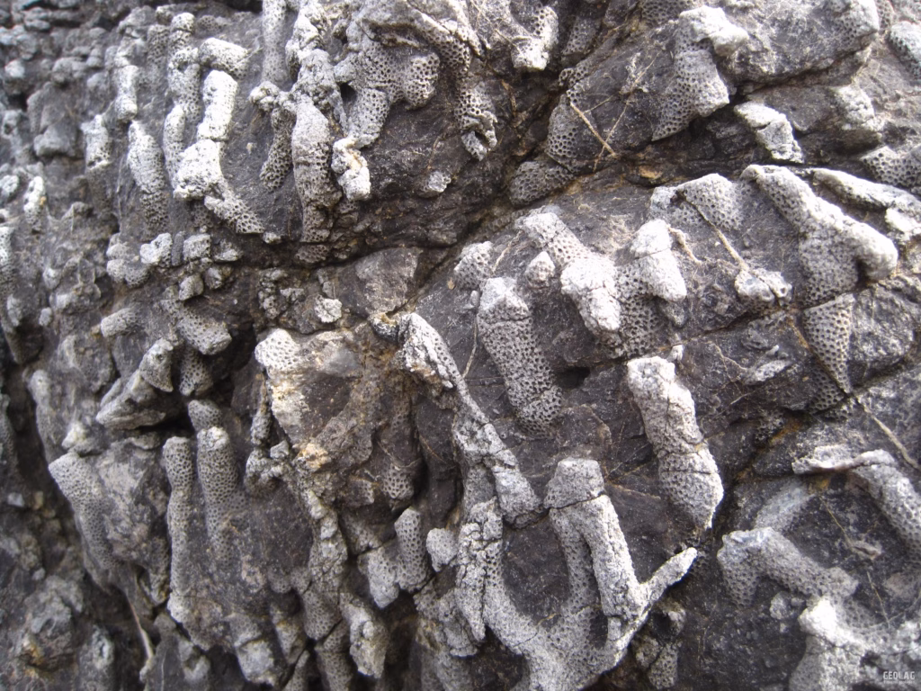
When Asturias was located in tropical conditions, during the Devonian, another type of rock was deposited: limestones. These are rocks formed by biochemical processes related to organisms living in reef environments; that is why it is normal for these rocks to contain many fossil remains of shells and other marine organisms. Specialists are able to recognize each species and assign them a specific age, which is how we know the age of the rocks. This is how the limestones found, for example, around Punta Moniello, between Bañugues and Luanco, were formed.

Thus, on this route, we will learn a little more about the remote origins of our region and see how rocks, like a book, provide us with valuable information layer by layer, just like pages.
Documentation:
- Geology of Asturias. Aramburu and Bastida. Trea Editions, 1995.
- Nature Itinerary Notebooks. The Cabo Peñas Region. Produced by the University of Oviedo and published by the Ministry of Education and Science in 2008.
Do you want to discover this landscape with a geologist?
GEOLAG organizes educational routes adapted for families, groups, and schools.
Request information about this route