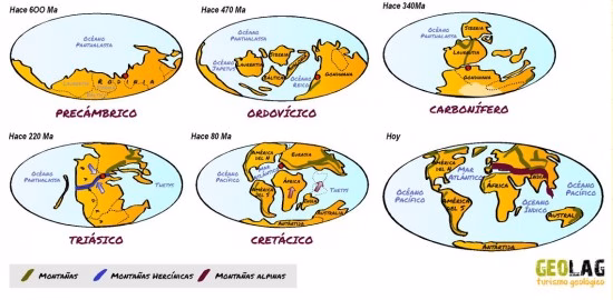
The Earth’s surface is made up of a series of tectonic plates that resemble the pieces of a giant puzzle. These tectonic plates move due to convection currents circulating inside the Earth, fueled by the heat emanating from the depths of our planet. The plates “float” on a mass of viscous rock called the mantle, and these currents cause the plates to move slowly, resulting, over millions of years, in changes in the distribution of the oceans and continents.
The Cantabrian Mountains, like all mountains on Earth, were formed as a result of the collision of various tectonic plates over the past 350 million years. The first collision occurred when all the continental masses came together to form a supercontinent called Pangaea (see the Triassic period in the figure above). The resulting mountain range was the result of intense compression (the Hercynian Orogeny), which created folds and fractures that ultimately uplifted the rocks that were being deposited on the seafloor and on land. This mountain range was of colossal dimensions and reached heights comparable to those of the present-day Himalayas, but subsequent erosion dismantled it, and the ancient mountain range was leveled.
Over millions of years, the continents drifted apart, and the Iberian Plate—on which part of the Iberian Peninsula lies—drifted like an island, gradually moving closer to its current position (red dot in the figure above). About 40–50 million years ago, the northward movement of the African plate finally caused it to collide with Europe, and at the collision zone, the Alps and the Pyrenees were formed, while the Cantabrian Mountains rose once again to take on an appearance similar to what we see today. Thus, the Cantabrian Mountains are the result of two orogenies: the Hercynian or Variscan orogeny and the more recent one known as the Alpine orogen y, so named because it was responsible for the formation of the Alps.
The rocks that make up the Cantabrian Mountains have accumulated over the last 600 million years and were formed under climatic conditions very different from those of today, due to the continuous movement of the Earth’s crust throughout Earth’s history. The Cantabrian Mountains contain rocks of very different types and ages, allowing us to reconstruct the long journey we have taken from locations near the South Pole to our current latitudes. Quartzites, sandstones, shales, conglomerates, coal beds, and limestones accumulated during that journey, and as a result of the Variscan and Alpine orogenies, these materials were compressed, folded, and fractured to form the present-day mountains. Since then, the softer rocks have gradually eroded due to the action of rivers, glaciers, and other processes, while the more resistant rocks remain, forming the highest areas of the mountain range. These higher areas constitute the main mountain ranges where we carry out our mountain activities (mountaineering, ice climbing, skiing, rock climbing, etc.), such as Los Ancares, Somiedo, Mampodre, San Isidro, Fuentes Carrionas, Ubiña, and the Picos de Europa.
In the case of the Picos de Europa and Peña Ubiña massifs, their distinctive feature is that they are primarily composed of limestone, a substrate that has made them stand out in the landscape, appearing as imposing rock castles. This is because limestone is a permeable rock that allows water to flow underground, forming chasms and caves within the limestone massif. As a result, the Picos de Europa are an international benchmark in speleology, as they contain around 300 km of underground passages and more than 3,000 documented caves, including 14 chasms deeper than 1,000 m (the deepest is 1,589 m). The Picos de Europa are home to 13% of the world’s chasms deeper than 1 km. Since water does not flow on the surface, it is difficult to find rivers and springs in limestone massifs; therefore, it is important to bring plenty of water for our activities.

In Ubiña and the Picos de Europa, the softer rocks in the surrounding area have gradually eroded, leaving the limestone to “survive” and stand out in the landscape. Thus, on the outskirts of the Ubiña Massif and the three massifs that make up the Picos de Europa, spectacular slopes with vertical drops of up to 2,000 meters have formed. On these dizzying rocky slopes, the action of ancient glaciers, as well as present-day torrents and avalanches, have carved out characteristic narrow, steep valleys known as “canals”—routes providing access to the high elevations of the massifs and a delight for lovers of steep terrain.
The limestones that make up these massifs were formed during the Carboniferous Period, about 300–350 million years ago, and were deposited on the seafloor when we were located in tropical latitudes. Under those conditions, the warm waters fostered the proliferation of marine organisms such as corals, crinoids, sponges, and others.

Over the course of about 20 million years, the remains of these organisms, together with the activity of algae and bacteria, created the largest accumulation of limestone on the entire planet during that period, covering an area of about 12,000km² and more than 1,500 m thick. When the limestone was subjected to the pressure and collision of continents, these layers fractured and piled up, causing their thickness to increase several-fold and giving rise to a massive limestone formation whose current boundaries are still unknown, as it extends beneath the Cantabrian Sea.
At the same time, lush tropical forest vegetation covered the exposed areas. The remains of tree trunks, leaves, and branches were quickly covered by other sediments resulting from the erosion of the newly formed landforms, thus preventing their decomposition. This is how the coal seams (hence the name “Carboniferous Period”) were formed—seams that are so abundant in various parts of the Cordillera and of great socioeconomic interest. It is estimated that 10 meters of fallen trees were needed to form a 1-meter-thick layer of coal.
Would you like to discover this landscape with a geologist?
GEOLAG organises educational routes adapted to families, groups and schools.
Request information about this route