The Saliencia Lakes are located in the Somiedo Natural Park (the first protected area in Asturias’ network of protected natural areas), which has also been a Biosphere Reserve since 2000. This territory is part of the European Natura 2000 Network, having been declared in 2004 a Site of Community Importance (SCI) and a Special Protection Area for Birds (SPA). As if that were not enough, the Somiedo lakes are included in the network of protected areas as the Natural Monument “Somiedo Lake District”. This natural monument includes the Saliencia lakes (Calabazosa or Lago Negro, Cerveriz, Laguna de Almagrera or La Mina and La Cueva), Lago del Valle and the high-mountain area located between these lakes and the southern boundary of the municipality of Somiedo, where the Picos Albos stand out. They are also listed as a Geological Point of Interest by the Spanish Geological and Mining Institute. As we can see, these lakes have very high natural values that have earned them all these recognitions, but…
But… why ARE THERE LAKES IN SOMIEDO?
It is surely a question we have never asked ourselves… they are simply there. However, if we look with a geologist’s eyes, we wonder how it is possible that in an area dominated by limestone these large bodies of water can still be maintained.
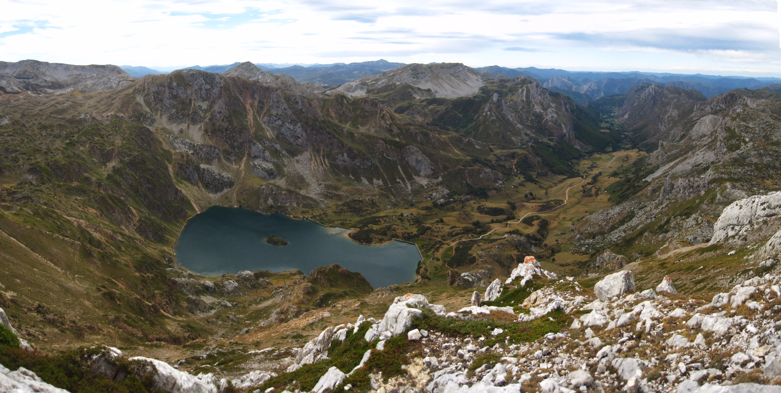
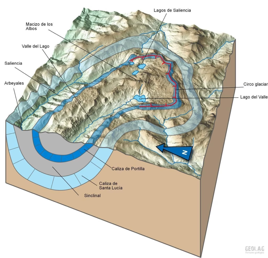
The Somiedo lakes, like most of the lakes found in many of the mountain massifs of the Cantabrian Mountains, have a glacial origin; that is, today’s lakes sit in basins produced by the overdeepening of glaciers into the rocky substrate. This is the case of the Somiedo lakes, separated from one another by rock thresholds of a certain height that the ice had to overcome to reach the lower areas, where it carved the broad and spectacular glacial valleys of Saliencia and Valle del Lago. This overdeepening of the bedrock reaches its maximum expression in Lago del Valle which, at 65 m deep, is the deepest lake in the entire Cantabrian Mountains. This erosive work by the glaciers has resulted in large accumulations of glacial materials generically known as till. Although it is true that in Somiedo the glacial deposits around the lakes do not seem very significant, they may have played a certain role in sealing the bottoms of the basins to allow water to be stored.
On the other hand, in Somiedo there is a factor that may be decisive in understanding the existence of some of the lakes in this limestone sector of the range. It is well known that limestone is a type of rock that undergoes dissolution processes with rainwater. This generates the landscape known as karst, which is so widespread in the higher parts of the three massifs of the Picos de Europa, in the Sierra del Aramo, Sierra de Gradura and in other limestone ranges. This dissolution is responsible for the fact that the entire interior of the limestone massifs is criss-crossed by countless shafts and galleries. In this way, all the water that falls on the surface enters the system of karst conduits and flows underground to lower areas, where it emerges through springs. The resulting landscape in the Picos de Europa is a set of dolines, large jous and sharp ridges. This characteristic dissolution means that in limestone areas it is not possible to retain water in the form of lakes. In fact, the Covadonga lakes owe their existence to the presence in that sector of slate materials that contribute to their impermeabilisation. However, in Somiedo, despite the same type of Carboniferous limestone outcropping, these elements are not observed: we have neither large jous nor dolines, and in many cases streams can be seen running across the undulating surface even during summer. And the most striking thing of all… here there are lakes! … and many!!
While the existence of Lago de la Cueva is due to the presence of a level of Devonian sandstones that makes its bottom impermeable, and Lago del Valle sits in a basin excavated into Carboniferous slates, in the case of Cerveiriz and Calabazosa Lakes the size of these lakes located on soluble limestone is striking. The solution to this enigma is a phenomenon that has caused a change in the mineralogical composition of these limestones: dolomitisation. This is a process in which magnesium (Mg) enters the system. In this case, the magnesium must have entered the crystal lattice of the limestone through fractures in the rock massif. Through these fissures, the influx of hydrothermal fluids loaded with minerals may have been the cause not only of dolomitisation, but also of the introduction of the iron mineral that colours the surroundings of Lago de la Cueva and which has been mined since the beginning of the 19th century at Santa Rita Mine.
During the dolomitisation process, some Ca atoms in the crystal structure of calcite (the mineral that forms limestone, with the formula CaCO3) are replaced by dolomite CaMg(CO3)2 , thus limestone becomes dolomite. Dolomite is not affected by karst dissolution, so the typical dolines of karst landscapes do not form on its surface. When dolomite weathers, it produces a sandy residue which, together with glacial deposits, has probably helped to fill the basins that now hold the lakes.
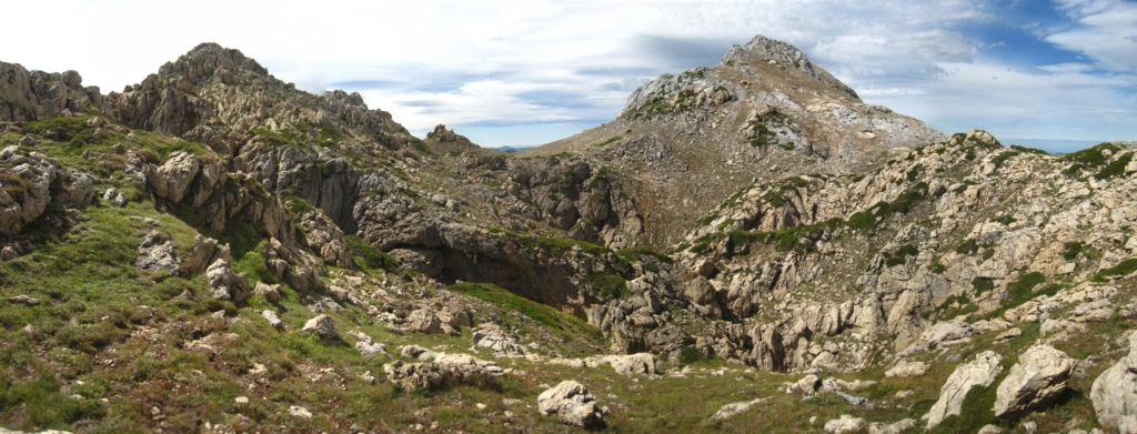
In the surroundings of the Somiedo Lakes, extensive areas can be seen covered by a field of rounded rises; it is a magnificent field of roches moutonnées. These forms were carved by the ice as it descended towards lower areas, so they are due to glacial erosion and not to karst dissolution as one might think, and they form regardless of the type of rock that makes up the substrate. It is true that in Somiedo there are some areas where broad crater-like depressions can be observed. In these large forms, collapses of underground galleries must have played an important role, showing that there are karstified limestones at some points inside the rock massif. Particularly striking are the collapses observed between Picos Albos and Picu Rubiu, of colossal dimensions.
Dolomites, which stand out for their orange and yellowish colours, can be observed along the entire head of the Saliencia and Valle del Lago valleys and, at times, it is possible to see dolomite crystallisations with their characteristic very flattened rhombohedral crystals.
Dolomite and toponymy
Dolomite takes on a different appearance and colour from the original white limestone rock, acquiring yellowish and brownish hues that are responsible for many place names in the area. Thus, Picos Albos (Albu Oriental and Albu Occidental) allude to the large white patches shown by both summits, which reveal areas of limestone that have not been affected by dolomitisation processes. In the same way, Picu Blanco is made up of unaltered limestone. Picu Rubiu, for its part, owes its name to the yellowish colour given by the dolomites that make up its entire surroundings.
Santa Rita Mine
The first news we have of this mine dates back to 1805, when reference is made to cannons made with iron from this mine. In the second decade of the 20th century the operation was open-cast, and extensive spoil heaps remain from that period. After a period of closure, activity resumed in 1956, this time with underground mining. In the 1960s, 300 workers were employed there, extracting an average of 100 tonnes/hour. In the early 1970s, production was estimated at 80,000 tonnes per year.
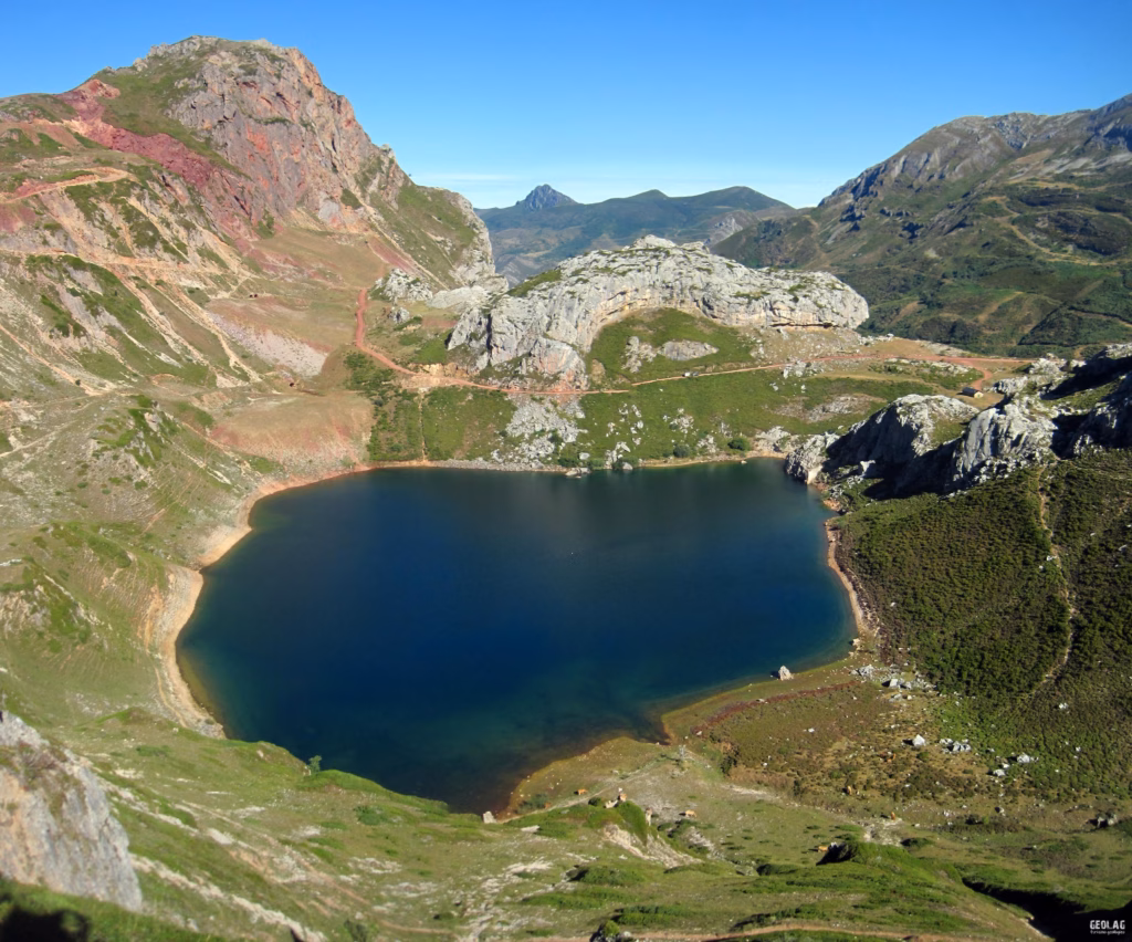
Lago de la Cueva was used to wash the ore, which was then transported to Torrestío and from there to Teverga, from where it reached the steelworks of Mieres or Gijón by railway. Laguna de La Almagrera owes its name to the red colour that tinged its waters, which may be because it was used in the early stages of the operation when only open-cast mining existed in the upper part.
The mine closed in 1978 despite estimates that at least 7 million tonnes of iron still remained to be extracted. In 1988 there were attempts to reactivate it, which were halted when the area was declared a Natural Park. This was the last iron mine in Asturias still in operation. In 1994 the first restoration work in the area was undertaken, which was completed in 2006.
Saliencia Valley and Valle del Lago
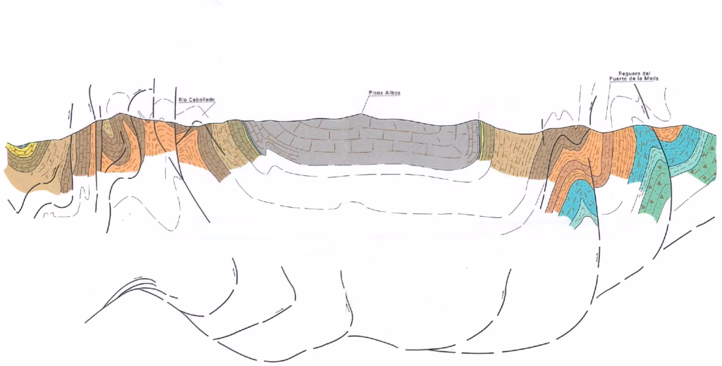
The direction of these valleys is due to the NW-SE orientation of the strata in this sector, and they take advantage of the softer materials in this area, composed mainly of Devonian slates and sandstones. Both valleys delimit the limestone massif where the Somiedo lakes are located which, due to its greater resistance, has remained elevated, forming the Albos massif. As a general rule, in Somiedo the strata are almost vertical, which gives the landscape a great variety of ridges and valleys that adapt to these layers, sometimes highly folded and faulted. However, in the lakes area the presence of a broad synclinal fold, where the Carboniferous limestones appear in the core with an almost horizontal arrangement, has favoured the exposure of a large limestone platform.
The Saliencia and Lago valleys are parallel valleys whose U-shaped morphology reveals their past as glacial valleys. In fact, the ice that accumulated in the higher parts of Somiedo descended through both valleys, eroding their walls until achieving this perfect U-shape. Today their slopes, freed from the strong pressure exerted by the ice on them, are subject to destabilisation processes, so rock avalanches (on the limestone slopes) and large landslides (on the sandstone and slate slopes) are common, such as those found on the approach to La Farrapona, which force the road to make several bends before reaching the pass.
Recommended route
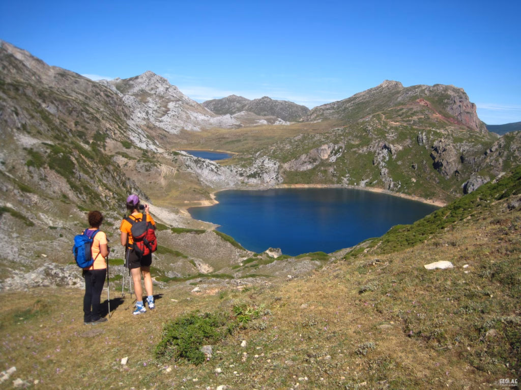
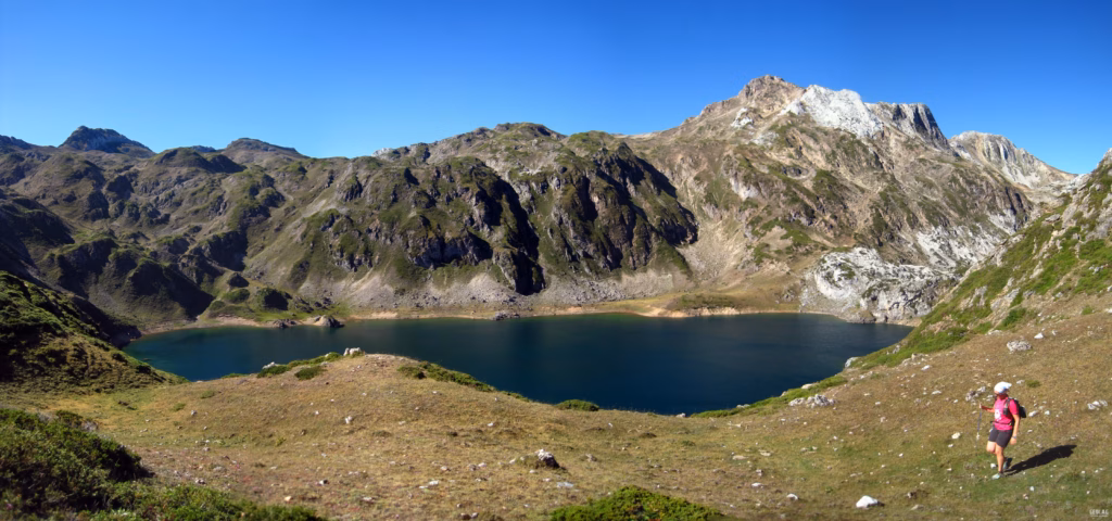
The hike to see all these landscape features can begin at Alto de la Farrapona, on the boundary between Asturias and León, heading towards Lago de la Cueva along a comfortable path. The red colour of the iron ore extracted here until the late 1970s stains the landscape, and the mine entrances and many of the spoil heaps of Santa Rita Mine are already visible. From this point it is awe-inspiring to think that the glacier that created the lake basin must have overtopped the rock threshold to plunge with a roar to the valley floor of Saliencia, forming a spectacular serac waterfall. A look towards Saliencia reveals the perfect U-shape of this valley, the result of the descent of a powerful glacier tongue. From Lago de la Cueva we will skirt its perimeter to the northeast to head to Collada Calabazosa, where we will have the first view of Calabazosa Lake, or Lago Negro, because of its deep, dark waters. From the south of the lake we will climb towards a broad meadow that holds the seasonal Calabazosa lagoons. On the way to the meadow we will have the opportunity to see two of the main lakes in the area: Calabazosa and Cerveiriz lakes, perfectly aligned along an almost E-W trending fault. From the Calabazosa Lagoons we enter uneven terrain, moving always with a tendency to the south, where Picu Blanco rises, with its characteristic light colour, and to its left Picu Calabazosa, whose easy ascent is recommended. Calabazosa offers views over Valle Congosto, already in the Leonese Babia, where the landscape contrasts sharply with its gentle slopes and dark colour. From this point it seems as if Somiedo were protected by a great limestone wall that extends to Peña Orniz and separates us from León. This limestone cliff is formed by Devonian limestones, older than those we have been walking on so far, which show their light colour and are not affected by dolomitisation. At the foot of this white cliff is a band of red limestones. This is the so-called Griotte Limestone, highly valued in construction and a true reference for geologists, as its presence marks the beginning of the Carboniferous.
After descending from Calabazosa we continue east towards the Albos massif, where the intense dolomitisation suffered by the entire massif is evident, giving the whole area a yellowish colour, broken only by a few white patches of limestone that have escaped the magnesium-rich fluids.
The ascent to Albo Occidental is highly recommended. To reach its summit we will use a comfortable path on its northwest slope, and from the top we will enjoy a complete 360-degree panorama of the entire Somiedo Park. At our feet lies Lago del Valle with its valley in perfect continuity. A perfect place to see one of the most complete glacial systems, with its glacial cirque, glacial lake and U-shaped valley—without doubt one of the most beautiful in the entire range.
All that remains is to descend along the same path towards Cerveiriz Lake, which lies to the north, not before passing through Vega Cebolléu, another meadow that floods seasonally. From Majada Cerveiriz we then connect with the mining track that links the ephemeral Laguna de La Almagrera with Lago de la Cueva. In the surroundings of the mine we will see some fine examples of dolomite crystallisations (no need to remind you that in a Natural Park it is forbidden to collect rocks, minerals, flora, etc.).
In 2016, Geolodía in Asturias was held at the Saliencia Lakes. For that event, GEOLAG collaborated with the Department of Geology of the University of Oviedo to produce a small geological guide, which can be consulted at the following link.
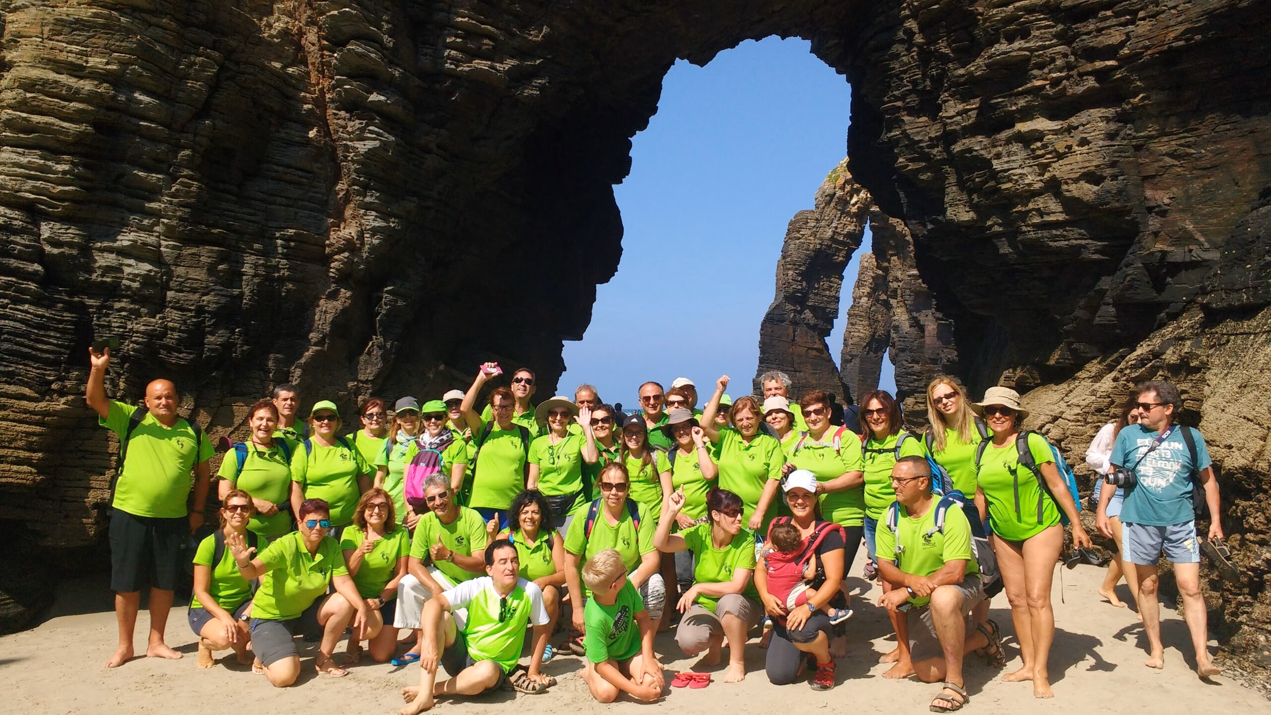
If you would like to do this guided hike with a geologist-guide, please do not hesitate to contact us about availability at info@geolag.com.
Recommended documentation
- Hiking topographic map of Somiedo Natural Park. Adrados Editions. See details
- The Babia region and the head of the Somiedo Valley. Nature itineraries. Teaching materials for secondary classrooms.
- Geology of Asturias. Trea Editions.
Photographs
Some of the photos illustrating this article can be seen at the following link: Somiedo lakes on GEOLAG’s Facebook page.
Would you like to discover this landscape with a woman geologist?
GEOLAG organises educational routes adapted to families, groups and educational centres.
Request information about this route